 放大圖片 放大圖片
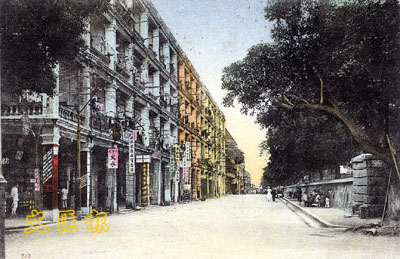
闢建於1860年代,原名依利近街或依利近道,1909年改為現名。早年為一條連接廣東道及彌敦道的運兵馬路。
左方的唐樓建於1900年代,到了1950年代中才陸續改建。
右方與彌敦道交界的地段早期為威菲路軍營,於1960年代後期轉變為九龍公園。
今日,海防道已由一運兵馬路化身為一遊客購物大道。
Haiphong Road
Constructed in 1860s. The name changed to Haiphong Road from Elgin Street or Elgin Road in 1909. It was a military road in 18 century.
The tenement buildings on the left were built in 1900s and rebuilt in 1950s.
To the right is the Whitfield Barracks situated at the intersection of Nathan Road, which become the Kowloon Park in the late 1960s.
Nowadays, Haiphong Road has changed to a shopping and tourist avenue from a military road. ■鄭寶鴻 香港歷史博物館名譽顧問
|
 放大圖片
放大圖片